
Ask anyone who has driven both the Ring of Kerry and the Dingle Peninsula which one they'd do again if they were back for a week. Most will say Dingle. Some will hesitate — the Ring is larger, the coastline is enormous, the views on a clear day are properly dramatic — and then say Dingle anyway. This is not to dismiss the Ring of Kerry, which earns its reputation when the timing is right. It's an honest observation about what the Dingle Peninsula actually delivers: a wilder, quieter, more concentrated version of Kerry that doesn't require you to get up at dawn to beat coach traffic. If you're planning the wider Kerry leg of a self-drive trip, our complete Ireland self-drive planning guide covers the broader decisions. But if you're here specifically to know what driving the Dingle Peninsula is actually like — the Slea Head Drive, the road into Dunquin, the Blasket Islands across the sound — this is the guide.
Dingle Town First
Dingle town is the natural base for the peninsula. It's a working fishing town — boats in the harbour, pubs that aren't performing Irishness for visitors — with a concentration of good restaurants for its size that catches most people off guard. There are around two thousand people living here. In peak summer it fills considerably, but even then it doesn't feel managed the way some Kerry towns do. It has a resident dolphin, Fungie, who disappeared in 2020 after spending thirty-five years in the harbour, which tells you something about the place: even the tourism stories are specific and a little strange.
Stay in Dingle town if you can. The Slea Head Drive starts and ends here, you can walk to dinner, and the morning light on the harbour before you leave is worth setting the alarm for.
The Slea Head Drive
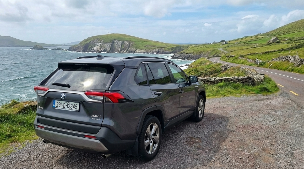
The Slea Head Drive is a 47km loop from Dingle town — west out past Ventry, around the tip of the peninsula at Slea Head, north to Dunquin and the Blasket Islands Sound, then back east through Ballyferriter and Murrioch. The whole circuit takes around three hours at a relaxed pace with stops; most drivers do it in four to five with the key pauses.
Leave Dingle heading west on the R559. The road runs along the southern coast of the peninsula past Ventry Strand — a long, sheltered beach that's usually quiet even in summer because most visitors are heading for Slea Head and don't stop here. It's worth a brief pull-in. From Ventry the road begins to climb and the Atlantic drops away below. This stretch — between Ventry and Slea Head itself — is where the peninsula starts to earn the reputation. The hills are treeless and green, the farms are small and walled in stone, and there are Iron Age promontory forts visible on the headlands that have been sitting there for two thousand years without anyone making much fuss about them.
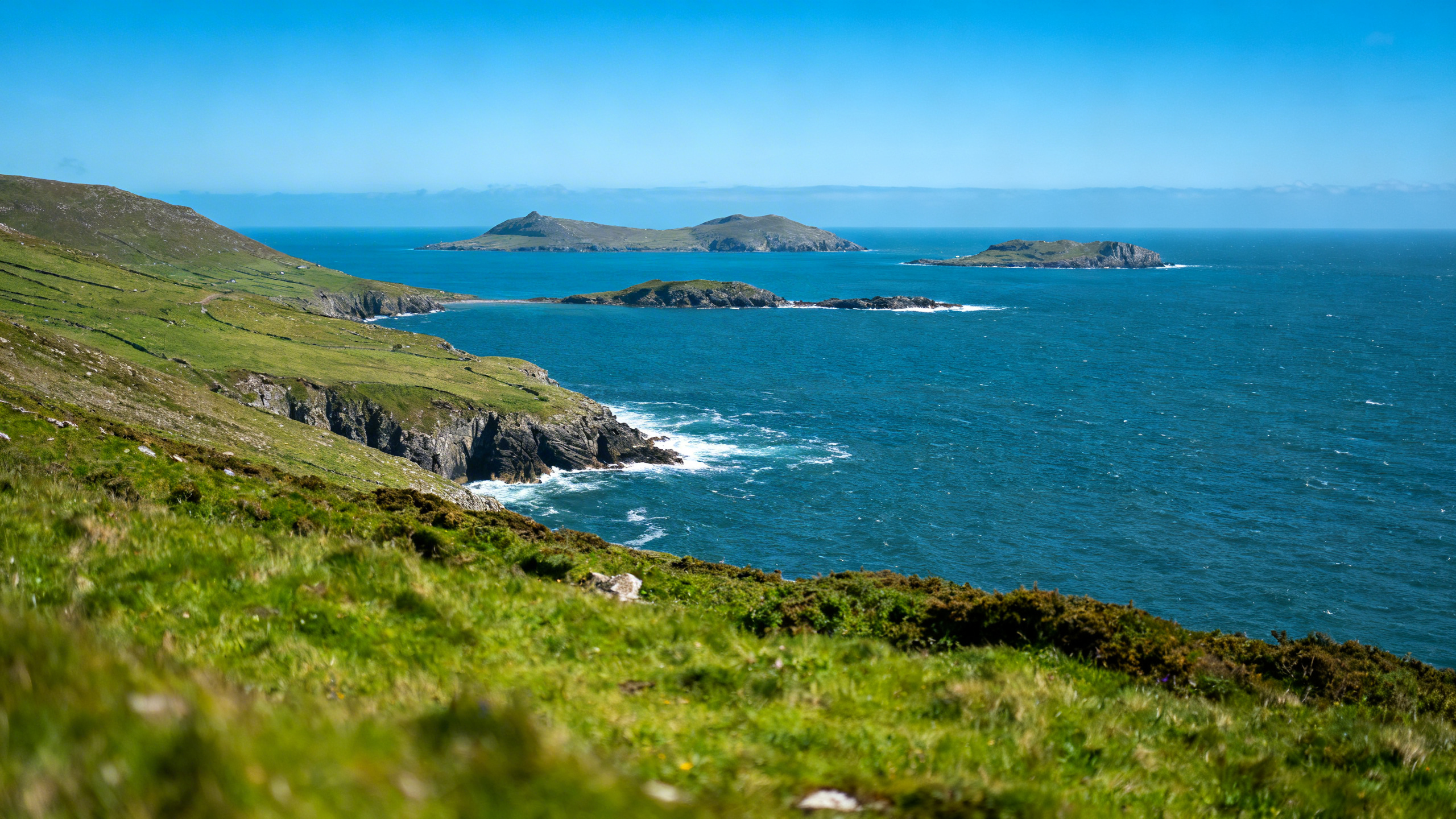
Slea Head itself is a lay-by with a stone cross and a view across the Blasket Sound to the Great Blasket Island. On a clear day you can see three islands: Great Blasket closest, Beginish to the right, and the sharp profile of Tearaght to the far west. Great Blasket was inhabited until 1953, when the last twenty-two residents were evacuated at their own request — the island was too remote, the population too small, the winters too hard. The uninhabited village is still visible on the eastern slope from the road. There is a Blasket Islands Visitor Centre at Dunquin, a few kilometres further on, which tells the story properly.
Dunquin and the Blaskets

Dunquin is the most westerly village on the peninsula and one of the most westerly in Europe. The pier here is the departure point for boats to Great Blasket Island from late April through September, weather dependent. The crossing takes about twenty minutes and you spend an hour or two walking the island — the old village, the beaches, the seals on the western shore. If you have a full day, take the boat. If you're doing the Slea Head Drive as a half-day circuit, the view from the Blasket Centre above Dunquin will do.
The Blasket Centre itself is free to enter and one of the better small museums in Kerry — the story of the island community and its writers (Tomás Ó Criomhthain, Muiris Ó Súilleabháin, Peig Sayers all wrote in Irish about life on the island) is specific enough to be genuinely interesting rather than generically "Irish heritage."
The Beehive Huts
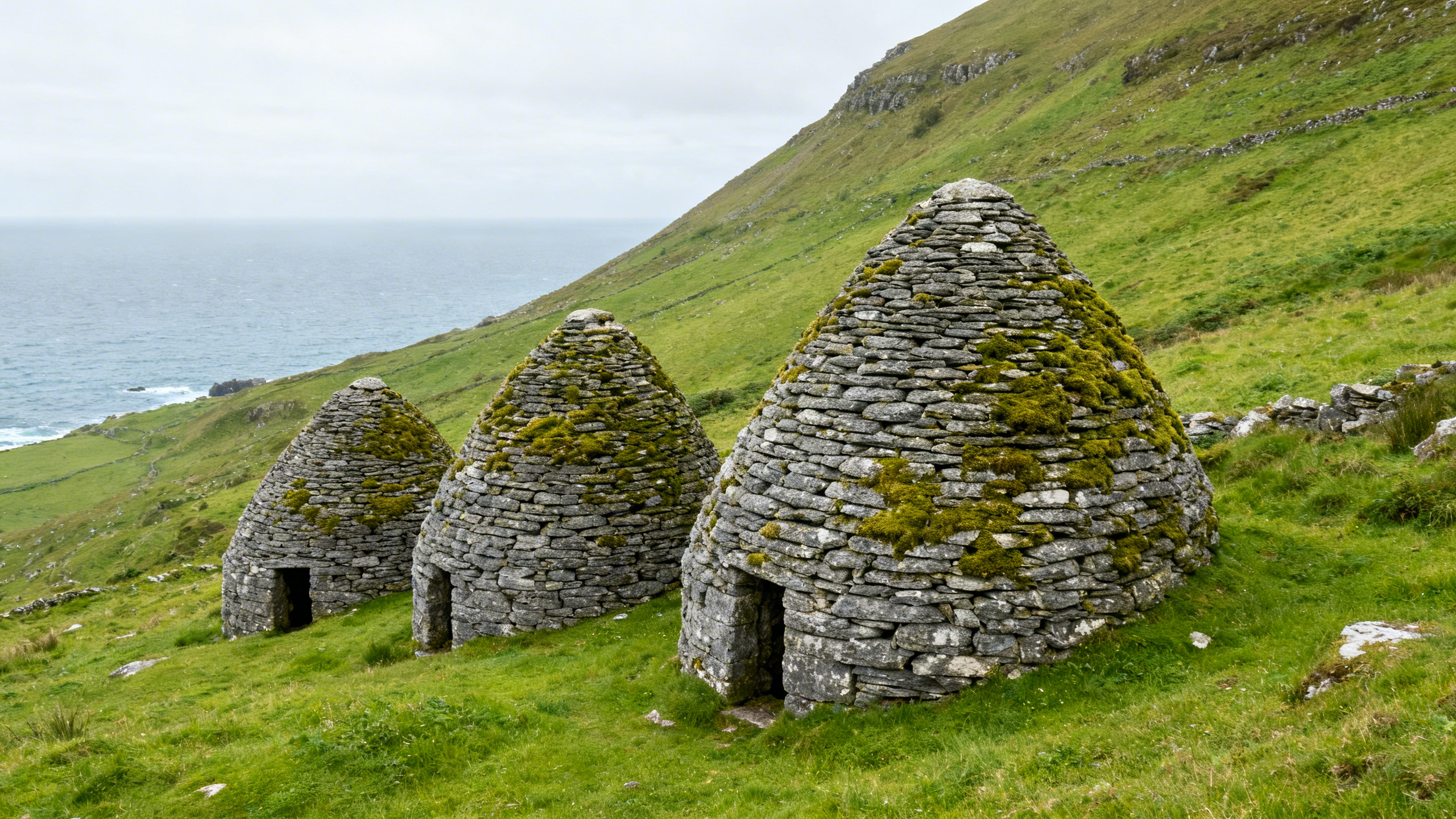
Between Ventry and Slea Head, the hillside above the road holds a collection of clocháns — dry-stone corbelled beehive huts built by early Christian monks, probably between the sixth and eighth centuries. They're visible from the road, signposted, and require a small entrance fee to a farmer whose land they sit on. There are around half a dozen huts in varying states of completeness, some intact enough to step inside. They give a better physical sense of monastic life on the Atlantic edge than the more famous Skellig Michael, which requires a boat trip and can only be visited in good weather.
The clocháns take fifteen minutes to walk around and are the kind of stop that rewards anyone who was wondering whether to pause. Stop.
The Road Back — Ballyferriter and Beyond
The northern leg of the Slea Head Drive runs from Dunquin east through Ballyferriter and Murrioch. This is quieter than the Slea Head section and the traffic is almost entirely local. Ballyferriter has a small pub. The road skirts the northern coast of the peninsula with views across Smerwick Harbour before rejoining the R559 back into Dingle.
If you have time, the road east from Dingle toward Tralee passes over the Conor Pass — at 456 metres, the highest mountain pass in Ireland accessible by public road. The views down into the glacial valley to the west are the kind that make drivers stop the car and look. In winter and early spring the pass is occasionally closed by ice or snow; check conditions before heading over if the forecast is uncertain.
Dingle vs Ring of Kerry — The Honest Assessment
The Ring of Kerry covers 179km around the Iveragh Peninsula. The Slea Head Drive covers 47km. The Ring takes a full day; so does Dingle, but a slower, different kind of day. On the Ring you are rarely alone at the key stops — coaches travel clockwise by convention and the viewpoints fill by mid-morning. On the Slea Head Drive there are no coaches. The road is too narrow and the turning points too tight. What you get instead is the road mostly to yourself, the westernmost edge of Europe, Iron Age forts, early Christian monks' huts, and a view across the sound to an island whose last residents left within living memory.
The Ring of Kerry is a bigger, more famous experience. Dingle is the more intimate one. Most drivers who do both — and you should do both if you have the days — say Dingle was the one they thought about afterward. Our complete Ireland self-drive planning guide covers how to structure a Kerry visit across multiple days if you're planning both routes.
How to Combine Dingle and the Ring of Kerry
Two days minimum. The Ring of Kerry is best done as a full day from Killarney or Kenmare, starting before 9am, going anticlockwise. The Ring of Kerry self-drive is a full day from Dingle town or Tralee. If you're based in Killarney, you can reach Dingle town in under an hour on the N22 north through Tralee and down the N86 — or over the Conor Pass if conditions allow.
For visitors who want a pre-arranged Kerry itinerary — accommodation booked at each stop, route planned, both routes covered without the logistics overhead — Celtic Vacations build Kerry self-drive packages that handle the accommodation juggle. If you want the freedom of self-drive without the hours of planning, they're worth a conversation before you book anything.
Practical Notes for the Slea Head Drive
The R559 is single-track with passing places on much of the western section between Ventry and Dunquin. In a standard hatchback this is entirely manageable — you will meet oncoming cars regularly and one of you will reverse to a passing place; this is normal and not stressful in practice. In a large SUV or a people-carrier, allow extra time and extra caution at the tight bends on the cliff section approaching Slea Head.
The roads into the beehive huts and the Blasket Centre car park are narrow. Standard cars have no difficulty; wider vehicles need care.
Fuel: Dingle town has a petrol station. There is nothing on the Slea Head Drive circuit itself. Fill up before you leave.
The drive can be done in either direction. Clockwise (the direction described above — west out of Dingle, around Slea Head, north to Dunquin) puts the best coastal section on your left and is the more natural flow with traffic. Some drivers prefer counterclockwise for the light in late afternoon. Either works.
Zero-Excess Cover on a Narrow Road
The cliff section between Ventry and Slea Head is the road where a slow scrape happens most often — not through any failure of driving, just the geometry of a single-track road with a stone wall on one side and a drop on the other, and an oncoming car appearing around a blind bend. Most drivers navigate it without incident. Some don't. When you're on a standard rental with an excess of €1,500 or more sitting on your credit card, that geometry focuses the mind in a way that is not actually compatible with enjoying the view.
My Irish Cousin's all-inclusive cover removes the excess entirely. No deposit held at pickup, tyre and glass covered as standard, full roadside assistance if you need it. If something happens on the Slea Head road, you call the number, they sort it, you continue the day. That is the practical version of the argument.
Frequently Asked Questions
How long does the Slea Head Drive take?
The 47km circuit from Dingle takes around three hours of driving. With the main stops — Ventry, the beehive huts, Slea Head, Dunquin, the Blasket Centre, Ballyferriter — budget four to five hours minimum. Most drivers spend a full day.
Is the Slea Head Drive suitable for nervous drivers?
The western section is narrow and requires care at passing places. If you've driven rural roads in the UK — a single-track Scottish road, a Cornish lane — Slea Head is comparable. The main requirement is patience at passing places and the willingness to reverse occasionally. It is not technically difficult.
Can I do the Slea Head Drive and the Ring of Kerry in one day?
Not comfortably. Both deserve a full day. From a Killarney base, plan one day for the Ring (anticlockwise, leaving before 9am) and a separate day for Dingle (drive over from Killarney in the morning, do the Slea Head circuit, return in the evening). Two days in Kerry is the honest minimum.
When can I take a boat to the Blasket Islands?
Boats run from Dunquin pier from approximately late April through early September, weather permitting. Departures are not guaranteed — the Sound is exposed and Atlantic swell can prevent crossings on short notice. If a Blasket trip is important to your visit, build flexibility into the day and check conditions with the boat operators in Dingle the evening before.
Should I drive over the Conor Pass?
In good weather, yes. It's the highest mountain pass in Ireland accessible by road and the views are exceptional. Check the weather and road conditions before heading over in early spring or late autumn — the pass can be icy or closed in winter. Coming from Tralee, drive over the pass to reach Dingle town; return via the longer northern coast road for a different view.
The Dingle Peninsula rewards the driver who arrived in Kerry expecting the Ring of Kerry and stumbled onto something better. The Slea Head Drive is one of those roads that justifies the whole trip — specific, unhurried, with an edge of the-world-ends-here that most scenic drives only promise. Go anticlockwise around the Slea Head circuit, stop at the beehive huts, park above Dunquin long enough to look across the sound at the Blaskets, and drive the Conor Pass if the sky is clear. Do those four things and you will have had a different day entirely to the one most visitors describe. Our complete Ireland self-drive planning guide covers the wider Kerry itinerary questions — how many days, which base, and how the peninsula fits into a full west coast self-drive.