
The Ring of Kerry is a loop. The Dingle Peninsula is a loop. Connemara is not a loop — it's a network of roads through bog, mountain, and lake that you can enter and leave from several different directions, and where the best moments are the ones that happen between the stops on the list. That sounds like a travel writer's way of saying there's no plan worth following. It's the opposite. It means you need a different kind of plan: a few anchor roads, a few fixed stops, and enough slack in the day to follow the bog road that you definitely don't need to take but that turns out to be the best hour you spend in the west of Ireland. This guide gives you the structure. What you do with the gaps is the Connemara part. If you're building Connemara into a wider west coast self-drive, our complete Ireland self-drive planning guide covers the broader route planning and where Connemara sits in the overall sequence.
Starting from Galway
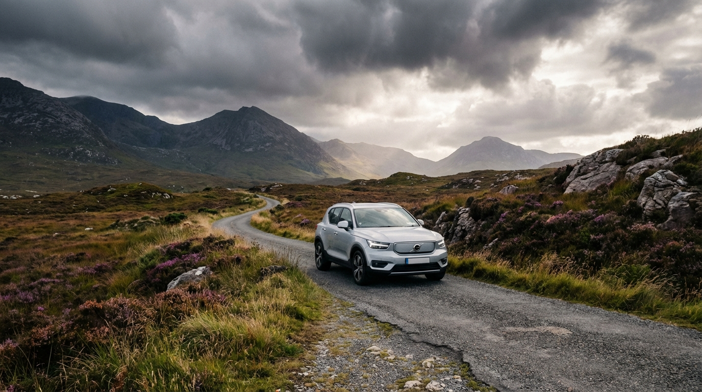
Connemara starts at the edge of Galway city and runs west until the land runs out. Most drivers approach it on the N59 — the road that leaves Galway heading northwest through Moycullen and Oughterard before opening into the big bog country beyond Maam Cross. This is the spine. The N59 links everything worth anchoring your day to: Clifden in the west, Kylemore Abbey in the north, and the road back east along the Killary Fjord if you're going in the right loop.
Base yourself in Galway city if you can. It's an hour's drive to Clifden on the N59 in clear traffic, longer on a busy summer day, and having a city base means you're not trying to find accommodation in the middle of a Connemara bog when you've run out of time and light. Galway also gives you an evening after the drive — a city with good restaurants, a real pub scene, and enough to occupy the hours between getting back from Connemara and going to sleep.
For visitors who want the Galway-and-Connemara combination without the accommodation juggling, Celtic Vacations build self-drive packages that pre-book your Galway base and map the Connemara day into the route. The driving stays yours — the logistics don't.
The N59 and What It Shows You
The drive west from Galway on the N59 changes at Oughterard. Before Oughterard it's a standard Irish national road — fine. After it, the bog opens. The Twelve Bens start appearing to the northwest: a compact range of sharp quartzite peaks that have a different quality of light to the Kerry mountains — harder, greyer, shorter on sentiment. The road runs through Maam Cross, a crossroads in the middle of nothing with a pub and a small service station that has been there long enough to have its own mythology, and then northwest toward Clifden.
The bog itself is worth attending to. It's not decorative — it's working landscape, cut in long straight lines where turf has been harvested, dark brown stacks drying by the road's edge in summer. The smell of a turf fire in a Connemara farmhouse, doors open in the evening, is specific enough to be the thing people describe when they're trying to say what Connemara smelled like. Pay attention as you drive through it.
Clifden and the Sky Road

Clifden is the largest town in Connemara, which makes it sound bigger than it is. It has three thousand people, a handful of pubs, a few restaurants that are genuinely worth a stop, and the best coffee in the region if you know where to look. It sits at the head of a narrow sea inlet with the Twelve Bens forming a wall to the east.
The Sky Road is the reason to come. It's a 12km loop from Clifden town — out the western headland, above the Atlantic, high enough to look back over the town and the bay below and the islands scattered across the water, then back east into Clifden. The road is narrow on the upper section — passing places every hundred metres or so — and the drop to the right is steep enough to be vertiginous if you stop and actually look. Do stop and actually look. The view at the highest point, on a clear day, is the western edge of Europe in miniature: the town below, the sea beyond, the light doing something with the Atlantic that it doesn't do anywhere else.
The Sky Road takes around 45 minutes at a relaxed pace with stops. Drive it clockwise — the single-track section is on the seaward side going out, which puts the best views in front of you.
Kylemore Abbey
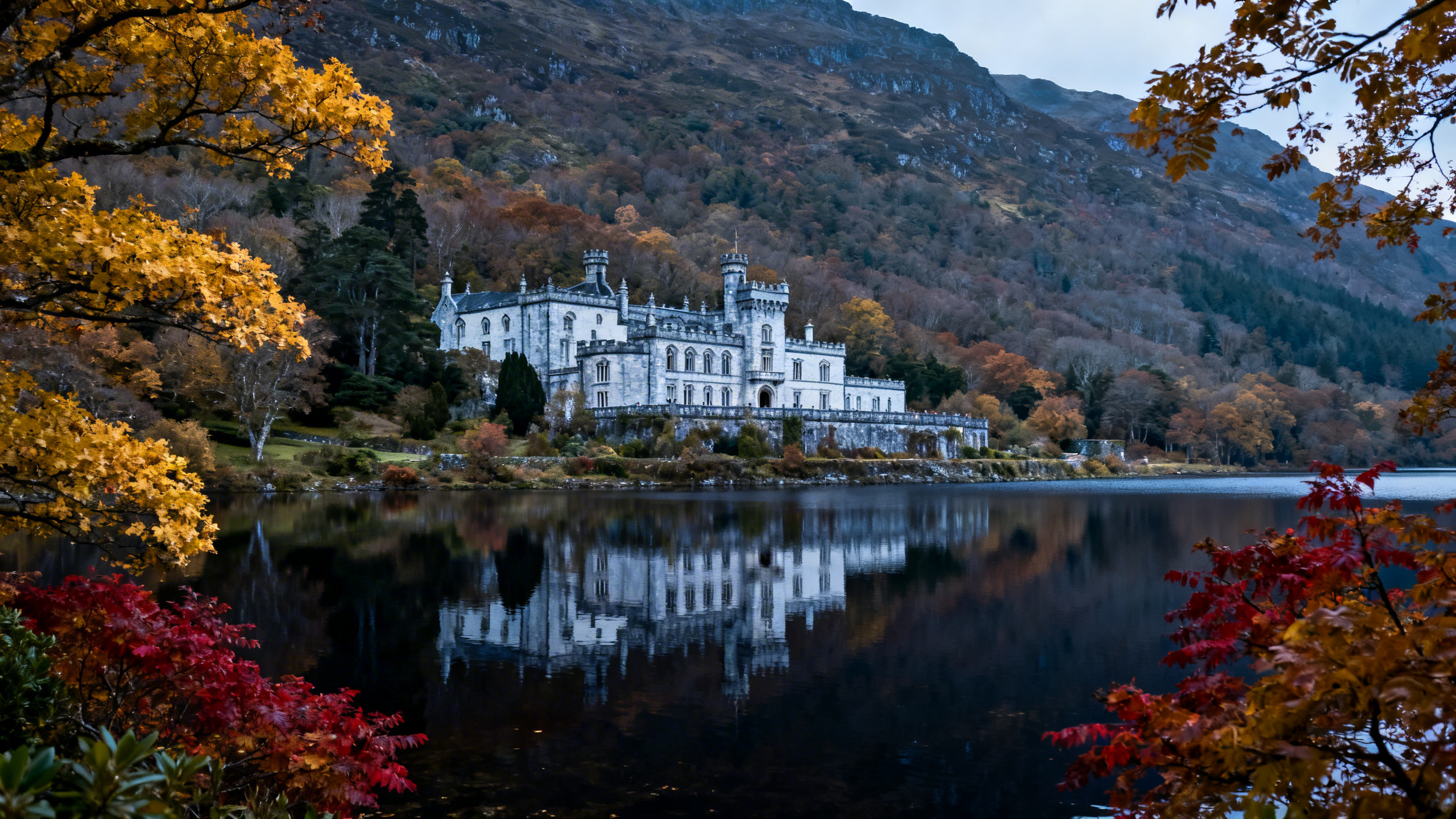
Kylemore Abbey is the most visited site in Connemara and is, on a busy summer day, exactly that. A Victorian castle reflected in a lake at the foot of a mountain, built by a Manchester merchant in 1868 as a gift for his wife, converted to a Benedictine convent in 1920, and now run by the nuns with a café, a Victorian Walled Garden, and the kind of car park that coaches reach first and leave last. None of that makes Kylemore less beautiful. The lake is real, the castle is genuinely extraordinary in its setting, and the restored walled garden is one of the better things in Connemara if you have an hour for it. The trick is timing: arrive before 10am or after 4pm and the crowds are manageable. Between those hours in July or August, it is a different experience.
From Kylemore, the N59 runs west toward Letterfrack, where the Connemara National Park visitor centre sits at the entrance to a short network of walking trails. Diamond Hill — the most accessible of the Twelve Bens — is a two-hour return walk from here with views across Connemara that no road gives you. If you have the legs and the footwear, go up. If you're doing it as a driving day, the view from the road at the Diamond Hill car park is enough to justify the stop.
Killary Fjord
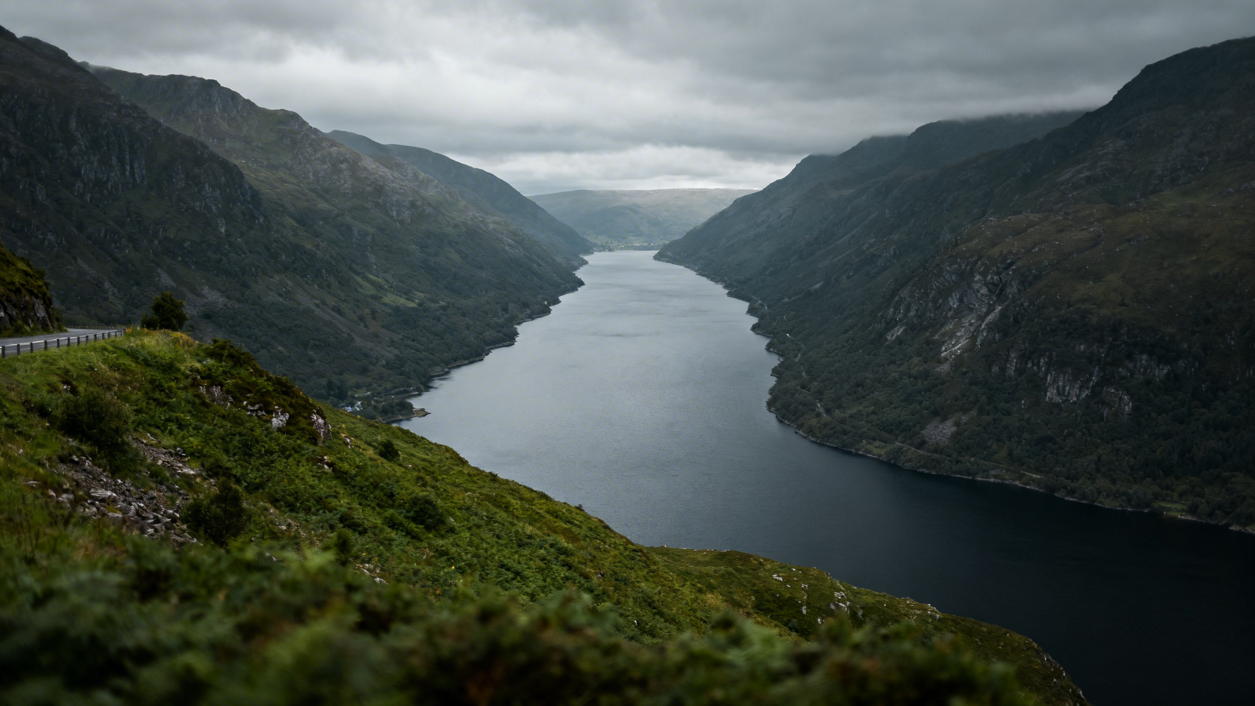
Killary Harbour is Ireland's only fjord — a 16km inlet that runs between the Mweelrea mountains of Mayo to the north and the Maamturks of Galway to the south, the water deep and still and narrow enough to look like a river from the road above. The R335 runs along its southern shore from Leenane east — a road that is worth driving slowly and stopping at the lay-by above the water at least once, to look across at the slope on the far side and understand what the word fjord actually means in practice.
Leenane at the western end of the fjord is a village with a pub and a sheep and wool museum that is genuinely strange and worth twenty minutes. From Leenane you can continue north into Mayo, or loop back south through the Inagh Valley and the heart of the Twelve Bens if you want to come back to Galway via a different road through the mountains. That loop — Leenane to the Inagh Valley south to the N59 east to Galway — takes around two hours without stops and is the best of the inland Connemara roads.
The GPS Problem
There is a specific issue with driving Connemara on GPS directions and it is worth naming plainly before you leave Galway. Google Maps and most sat-nav systems route you along roads that appear on the map as minor regional roads but that are, in practice, single-track bog lanes with passing places every 300 metres and no tarmac at the edges. The times shown are based on distance, not on the road conditions or the geometry. A road that Google estimates at 25 minutes may be a 45-minute drive at a pace that doesn't damage your car.
This is not a problem if you know it in advance. It is a significant problem if you are holding the sat-nav as a reliable countdown and have a booking at 7pm. The rule in Connemara is to add 50% to any Google Maps driving time on an R-road or unclassified road, and never to commit to a fixed dinner time without that buffer built in. The N59 is reliable. Anything off it is a different calculation.
Roundstone and the Southern Coast

The southern loop of Connemara — the R341 from Clifden southeast through Ballyconneely and Roundstone before rejoining the N59 near Recess — is the road that most visitors miss and most Connemara regulars consider the better half of the day. Roundstone is a small fishing village on a sheltered harbour with Errisbeg Hill behind it, a traditional music instrument maker (Malachy Kearns, the only maker of the bodhrán in Ireland still operating out of a proper workshop), and a pub that serves good food. The beaches on the Ballyconneely peninsula west of here — Gorteen Bay, Dog's Bay — are white-sand coves with a quality of colour that is genuinely unusual: turquoise water and white strand in front of bog and mountains, like the landscape is disagreeing with itself.
This loop adds roughly 45 minutes to the standard Clifden–Kylemore–Killary day. If you're choosing between doing the southern coast and the Killary loop on the same day, do the southern coast — it's less known and more immediately beautiful in a way that photographs badly and stays in the memory well.
Connemara as Part of a Wider West Coast Circuit
Connemara doesn't exist in isolation — it sits in the middle of the Atlantic coast, and most visitors who drive it are also doing the broader west of Ireland. From Leenane, the road north into Mayo and toward Westport puts you directly onto the Wild Atlantic Way — that's the natural handoff if you're heading north after Connemara. If you're coming from or going to Kerry, the Ring of Kerry is the natural companion piece to the south — similar in reputation, different enough in character to justify doing both. For a full week in the west that includes Connemara as a centrepiece day, the 7-day Ireland self-drive itinerary maps out the route day by day.
No-Excess Cover on a Connemara Road
The roads off the N59 are the roads where the scrapes happen. A stone wall close to the tarmac edge on a dark bog lane, an oncoming tractor on a road that was barely wide enough before the tractor arrived, a passing place that you reversed into slightly too fast and found a shallow drain on the left. None of these are driver failures. They are the geometry of single-track roads in the west of Ireland, and they happen to careful drivers in small cars on perfectly ordinary days.
With a standard rental excess of €1,500 or €2,000 sitting on your credit card, that geometry has a cost. My Irish Cousin's all-inclusive cover removes the excess entirely — no deposit held at pickup, tyre and glass covered as standard, full roadside assistance if you need it. If something happens on a Connemara bog road, you call the number, the car is sorted, and you continue the day. That is the practical version of the argument for taking it.
Frequently Asked Questions
How long does a Connemara self-drive take?
The standard day from Galway — N59 to Clifden, Sky Road, Kylemore Abbey, Killary Fjord, back east — is around 6 to 7 hours with stops. The southern coast loop (Ballyconneely, Roundstone, Dog's Bay) adds 45 minutes to an hour. Budget a full day and leave Galway before 9am.
Is Connemara suitable for nervous drivers?
The N59 is straightforward — two lanes, well-surfaced, no unusual demands. The Sky Road and the southern coast roads are narrow with passing places but entirely manageable if you've driven rural roads anywhere in the UK or Ireland. The lanes on GPS shortcuts are the main trap — stay on marked R-roads and avoid anything Google routes you onto that isn't coloured yellow or orange on the map.
Can I do Connemara and Galway in one day from Dublin?
Not comfortably. Dublin to Galway is 2 hours on the M6 motorway. Add the Connemara day and the return journey and you have 10+ hours of driving to fit around any actual stopping. Spend a night in Galway, do Connemara as a full day, and return from Galway to Dublin the following morning.
What is the best time of year to drive Connemara?
May, June, and September offer the best combination of weather and manageable crowds. July and August are busy, particularly at Kylemore Abbey, but the weather is most reliable and the evenings are long enough to be in the bog at 8pm in full light. Winter Connemara is extraordinary — empty roads, dramatic light, genuinely wild — but some accommodation and minor visitor sites are closed.
Should I go to the Dingle Peninsula or Connemara?
They're different enough that the comparison doesn't hold well. Dingle is a defined circuit — a day, a direction, a set of specific stops. Connemara is a landscape to spend time in rather than a route to complete. If you have a week in the west, do both and give each a full day. If you have one day west of Dublin, Connemara rewards the less-structured driver more.
Connemara gives you as much as you're willing to slow down for. The Sky Road is worth it. Kylemore is worth it despite the coaches. Killary is worth it if only for the thirty seconds you stand above the water and understand why the word fjord applies. And the bog road you take because it looks interesting on the map and adds twelve minutes to the journey — that one's worth it too. Drive the N59 west, follow the Sky Road, take the southern coast back, and leave enough time in the middle to stop for no particular reason and look at a mountain.